
Pan di Zucchero, symbol of Iglesias: discover a wonder of Sardinia
The Pan di Zuccheroin the territory of the municipality of Iglesias, is one of the the island's most impressive and spectacular natural monuments and the entire Mediterranean. This guide will take you on a discovery of this jewel of the iglesiente coastbetween breathtaking views, history mining, splendid beaches and trekking possibilities. If you are planning a trip to this area of the Sardinia, this article will help you learn more about the area and better plan your visit.
Where is Pan di Zucchero?
The Pan di Zucchero is located along the south-west coast of the Sardiniain the territory of the municipality of Iglesias, at Masua. It is located in front of the small beach of Masua, about 20 kilometres from the centre of Iglesias.
It is part of the splendid iglesiente coast, known for its cliffs and mining history. The stacks rise a few metres from the shore, right in front of the impressive Porto Flavia mining complexand is easily accessible by car along the SP83
How to get to Pan di Zucchero from Iglesias?
Reaching the Pan di Zucchero is simple. From the centre of Iglesias, just about 20 km along the SP83 road towards Masuaa small coastal town belonging to the municipality of Iglesias. The road is well signposted and runs through a picturesque coastal landscape.
For those arriving from Cagliari (approximately 80 km), first drive along the SS130 to Iglesiasand then continue along the coast. The Faraglione is easily visible from the coastal road and the various vantage points.
What is the history and geology of Pan di Zucchero?
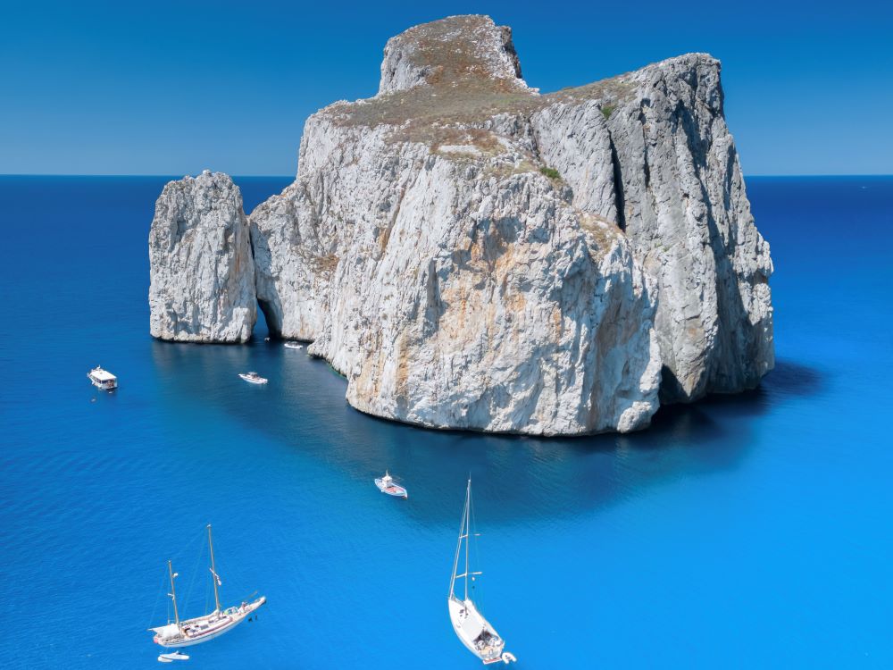
The Pan di Zucchero is the highest stacks in the Mediterraneanrises from the sea to 133 metreswith a massive, rounded shape dominating the iglesiente coast. This spectacular formation consists of cambric limestone, chemically almost pureshaped over the centuries by the action of themarine erosion. This process has generated the detachment from the mainland and moulded the two tunnel-shaped caves which open at sea level.
La limestone outline in all shades of yellow and orange has become the symbol of the coast and an integral part of the natural monument recognised since 1993. The name 'Pan di Zucchero' was inspired by Rio de Janeiro's famous Pão de Açúcar, due to its similar shape.
Are there any excursions to see Pan di Zucchero?
Set off from Buggerru marina on board an approximately 8-metre dinghy with an experienced skipper (who speaks Italian and English) and spend around 2½ hours exploring the picturesque Mines Coastin the deep south-west of Sardinia
Where to see the best sunset on the Pan di Zucchero?
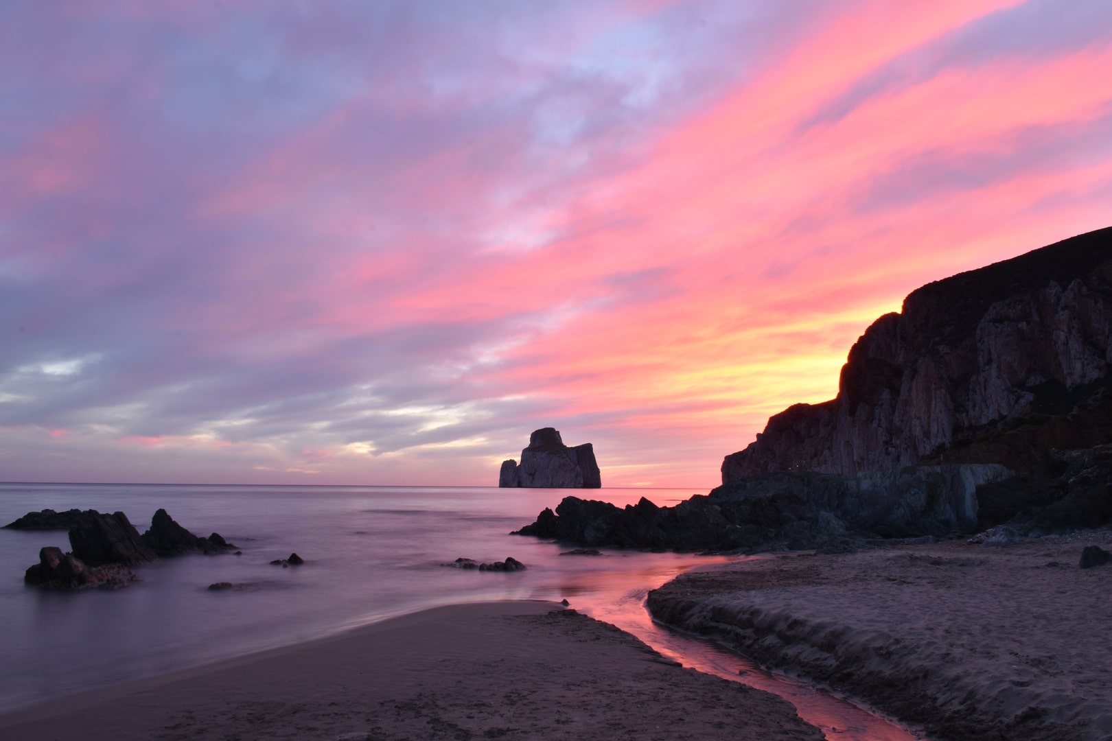
One of the most magical moments to admire the Pan di Zucchero is at sunsetwhen its walls rocky are tinged with red and orange. The best vantage points are found along the magnificent inlet of Masuawhere you can witness an unforgettable sunset with the Faraglione silhouetted in in the middle of the sea.
Other suggestive places are the panoramic terrace of Porto Flavia and the small beach of Masuaperfect for taking photographs.
Where to sleep near Pan di Zucchero?
There are several accommodation facilities in the area. A Masua and along the coast you can find small family-run hotels, B&Bs and holiday homes nestled in the maquis.
A Iglesiasonly 15-20 minutes away by car, the offer is even wider, with hotels of all categories. The advice is to choose a property with a view of the iglesiente coast or close to the beaches, so as to make the most of the beauty of this corner of Sardinia.
What are the best beaches near Pan di Zucchero?
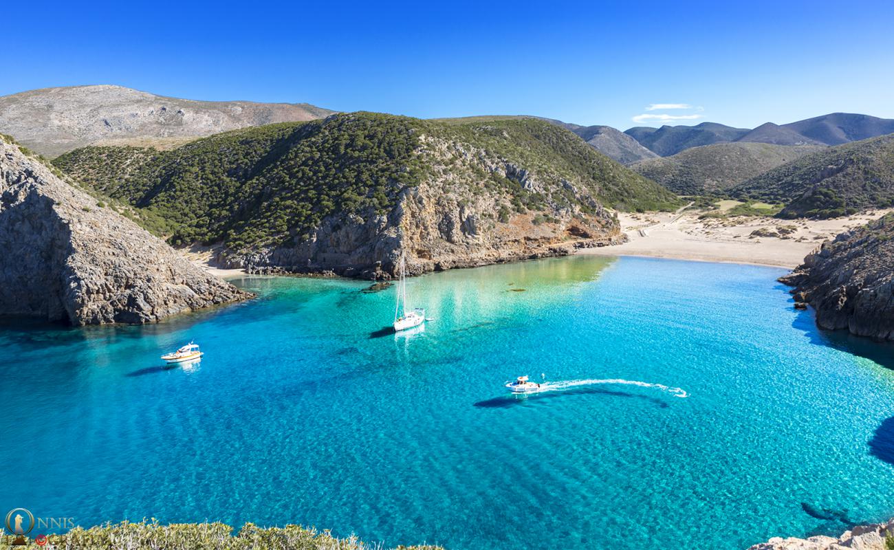
La iglesiente coast offers spectacular beaches. The beach of Masuaa few minutes from the Faraglione, is a beautiful bay of golden sand and rocks, ideal for relaxing while admiring theimposing rock.
Not far away we find Cala Domesticaa small bay enclosed between cliffswith fine sand and crystal-clear waters.
About 20 km away is Porto Pagliawith wide golden sandy shores and an unspoilt landscape, perfect for those seeking tranquillity.
What does the magnificent Masua inlet have to offer?
La magnificent inlet of Masua is a true oasis for sea and nature lovers. Its clear waters are perfect for swimming, snorkelling or kayaking along the cliff and between the minor reefs.
The varied seabed and the water tones, ranging from deep blue to turquoise, offer a unique view. The beach is well sheltered from the winds and ideal for spending entire days relaxing.
What to see in Porto Flavia?
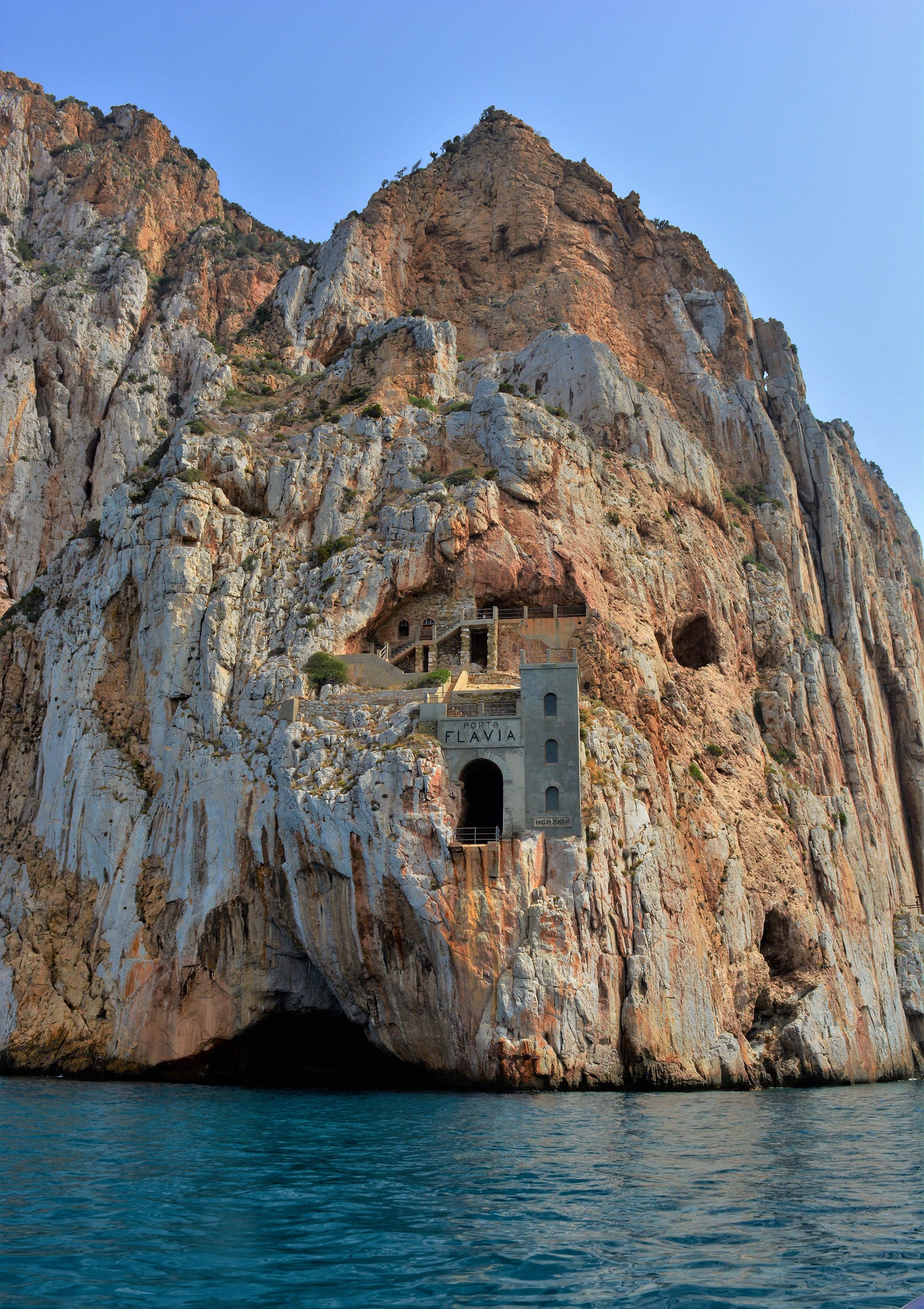
An unmissable experience is a visit to the Porto Flavia mining complexlocated high above the coast. This extraordinary site tells the story of the industry mining of the region and represents one of the great engineering works of the 20th century.
Through guided tours with specialised guidestunnels carved into the rock are explored, the mining of Porto Flaviawhich overlooks the Pan di Zucchero. The entire area, including the viewing terrace, offers spectacular views and numerous photo opportunities.
What treks to do in the Masua area?
The area of Masua and the sulcis iglesiente is also perfect for those who love trekking. Numerous scenic trails cross the bays of Portothe ancient structures mining and crags.
One of the most beautiful routes is the trek from Masua and goes up towards the Grand Canalan imposing rocky gorge. During the hike, you can admire the limestone formations, the violet-hued coastline and the cavities excavated by themarine erosion.
For the more experienced, the peak crag and the paths up to the surrounding heights offer breathtaking views and the possibility of spotting local fauna.
Where can I find a detailed map of the area?
For those who want to explore the area to the fullest, it is useful to obtain a good map. At the tourist office of the municipality of Iglesias, in the city centre, you can pick up updated maps and guides of the area.
Alternatively, many local guides offer detailed maps and advice on the best trails and viewpoints. Also on the official tourism website of the municipality of Iglesias downloadable maps can be found.
How to take beautiful pictures of the Pan di Zucchero?
The Pan di Zucchero is one of the most photographed subjects of the iglesiente coast. For spectacular images, the best time is definitely at the sunsetwhen the limestone outline with all shades of yellow stands out against the orange sky.
Good vantage points are the beach at Masuathe terrace of Porto Flaviaor the scenic paths towards the Grand Canal.
For those who practice climbing, the area is popular with the climbing enthusiasts, which find perfect walls around concali on terràinu and in the harbour inlets.
At a glance: what to remember about the Pan di Zucchero
The Pan di Zucchero is the highest stacks in the Mediterranean, high 133 metres
It is part of the most impressive natural monuments of Sardinia
Easily accessible from municipality of Iglesiasalong the iglesiente coast
Perfect to visit for those who love the sea, nature, history and tourism active
Beautiful sunsets from magnificent inlet of Masua and by Porto Flavia
Excellent hiking trails and guided hiking possibilities
Rich history mining and breathtaking landscapes
Spectacular photographs in every season
Ideal area for a holiday combining relaxation, adventure and culture
I hope this guide has been helpful to you in organising your visit to the Pan di Zucchero and its surroundings. All you have to do is prepare theequipmentcamera, and set off to discover one of the most beautiful corners of the Sardinia.